Spotlight on Citizen Science: CrowdMag
By: NOAA Office of Education
07 August 2017
Asking a college student to use a cell phone for science sounds like a breeze. But rather than wind, a project this summer involved geomagnetic data, and students contributed to CrowdMag a #citizenscience project developed by NOAA National Centers for Environmental Information – Ocean & Geophysics.
The “CrowdMag Day” campaign at the University of Colorado this summer harnessed the power of several student interns as citizen scientists. The summer interns were participating in the Research Experience for Community College Students (RECCS) program. RECCS is a nine-week summer student research program in critical zone science for community college students in Colorado funded by the National Science Foundation. The program is coordinated by NCEI, the Cooperative Institute for Research in Environmental Sciences (CIRES) Cires Education Outreach , the University of Colorado, and the Boulder Creek Critical Zone Observatory.
RECCS student researcher Anjelique Morine is mentored by CIRES research scientists Rick Saltus and Manoj Nair who are part of the Geomagnetism team with the NOAA National Centers for Environmental Information (NCEI) based in Boulder, Colorado. (Photo by Jennifer Taylor / CIRES)
For CrowdMag Day, teams of interns used the CrowdMag cellphone app to measure the Earth’s magnetic field on a common traverse along Boulder bike paths. Analysis of magnetic data from multiple cell phones provided insights into the data stability of different types of phones. The teams also helped in the understanding of the amplitude and scale of urban infrastructure that can interfere with magnetic signals, specifically bridges, overpasses, underpasses, and intersections.
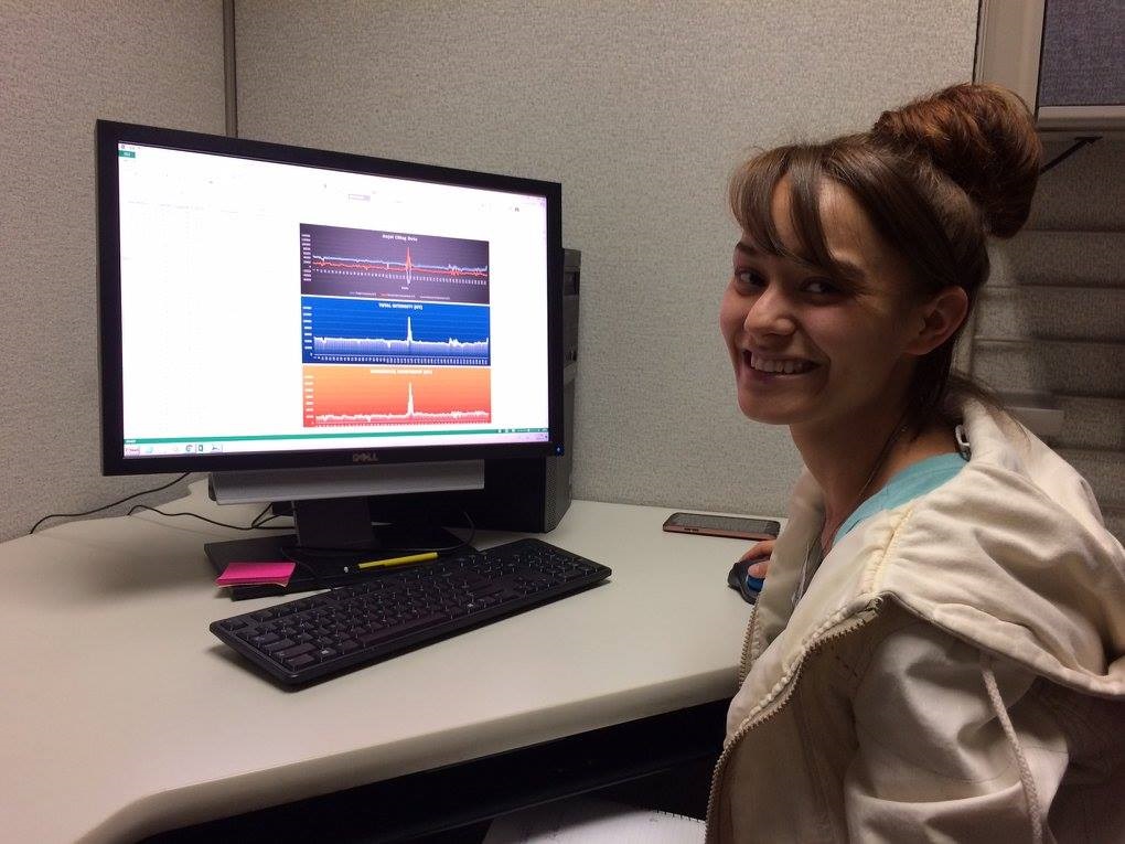
The group collected data by walking along bike paths for about two miles. These data represent the first-ever multi-phone, urban magnetic anomaly collection using CrowdMag, an app that is easily downloaded for free on smartphones. The project successfully received and processed data from a dozen individual phones.
The phones captured views of the magnetic environment along the traverse. Each phone record indicates several distinctive urban magnetic features, shown by magnetic anomalies. Each of these distinctive magnetic features corresponds to an urban infrastructure feature, such as a bridge or overpass. Researchers will use the data to understand the magnetic disturbances caused by man-made objects in the environment. The largest anomaly feature from the Colorado traverse (seen between points 97 and 115 on the plot) may have included an active magnetic source such as a DC electrical current flow.
About CrowdMag
In partnership with CIRES, NOAA’s NCEI started the CrowdMag project to collect vector magnetic data from digital magnetometers in smartphones. The aim is to test whether researchers can obtain meaningful magnetic data from a large number of noisier measurements thereby filling some of the gaps in the global magnetic data coverage.
Using a phone’s internet connection, magnetic data and location are sent to NOAA. The quality of the magnetic data is checked and then made available to the public as aggregate maps. Currently, the CrowdMag project has about 16,000 users who have contributed more than 24 million magnetic data points from around the world.
A unique contribution of the CrowdMag project is the collection of ground level magnetic data in densely populated regions. A team of geomagnetic scientists at NCEI hopes to use the data to create magnetic anomaly maps of urban regions. If validated, these magnetic urban footprints have a wealth of potential uses in navigation applications.
Learn how to become a CrowdMag citizen scientist: https://www.ngdc.noaa.gov/geomag/crowdmag.shtml
FAQ about Geomagnetism: https://www.ngdc.noaa.gov/geomag/faqgeom.shtml
This spotlight originally appeared on the NOAA Education and Outreach Facebook page
