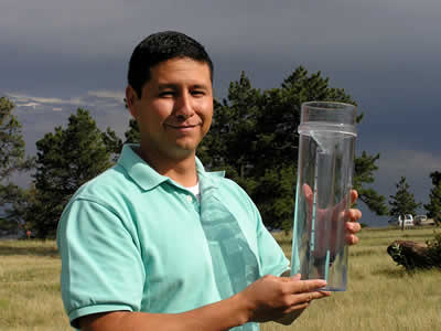
A CoCoRaHS volunteer with his rain gauge. Photo credit: NOAA/CoCoRaHS.

An official website of the United States government
The .gov means it’s official.
Federal government websites always use a .gov or .mil domain. Before sharing sensitive information online, make sure you’re on a .gov or .mil site by inspecting your browser’s address (or “location”) bar.
This site is also protected by an SSL (Secure Sockets Layer) certificate that’s been signed by the U.S. government. The https:// means all transmitted data is encrypted — in other words, any information or browsing history that you provide is transmitted securely.
A CoCoRaHS volunteer with his rain gauge. Photo credit: NOAA/CoCoRaHS.
In 1997, following an evening of intense rainfall in parts of Fort Collins, Colorado, an ankle-deep creek running through Colorado State University became a raging river of mud and debris. The Spring Creek Flood left five people dead and city-wide damages of more than $200 million — all for lack of warning. No one realized how much rain had fallen in the area, and traditional forecasting methods failed to predict such extreme flooding.
In response to the disaster, the Colorado Climate Center at Colorado State University launched a project to engage local citizens in collecting data on rainfall and other kinds of precipitation. The main goal of the Community Collaborative Rain, Hail and Snow Network, or CoCoRaHS, is to provide a way for volunteers to collect and submit local precipitation data and educate the public.
Download this case study (PDF, 82KB)
Website: Community Collaborative Rain, Hail and Snow Network
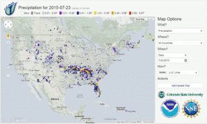
CoCoRaHS data displayed on a map.
Co-sponsored by the National Oceanic and Atmospheric Administration and the National Science Foundation, CoCoRaHS is for citizen scientists of all ages and from all walks of life who can spend a few minutes per day collecting information on precipitation in their area. Volunteers register their location on the project website and can train themselves online or in person with a local coordinator. By following a set of simple procedures and using a standardized rain gauge, volunteers measure and report their daily amount of rain (or melted snow) on the project website, making the data readily available in a centralized database at the touch of a fingertip. Options to report hail and/or other kinds of weather are also available, as well as advanced options such as evapotranspiration and drought impact reports.
From its origins in Colorado, word of CoCoRaHS spread, and scientists began requesting support for data collection across the United States. CoCoRaHS responded by offering newly participating states access to its technological platform but requiring each state to establish its own network of volunteer leaders responsible for recruiting, training and retaining local monitors. Motivated local leaders have helped expand CoCoRaHS to more than 20,000 active volunteers in all 50 states as well as Washington, D.C. (including the White House!), Puerto Rico, the U.S. Virgin Islands and most provinces in Canada.
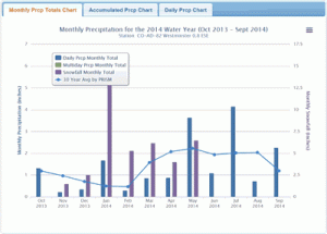
Example of CoCoRaHS data displayed with monthly totals compared to the 30-year average.
With volunteers in many different locations, ensuring data quality is a challenge. Volunteer coordinators and CoCoRaHS staff members monitor the maps and reports and are able to fix most errors. Also, CoCoRaHS volunteers are required to measure precipitation with standardized rain gauges with accuracy to the nearest hundredth of an inch. The cost is around $35 for the rain gauge, discouraging participation by some potential volunteers.
Another challenge is volunteer retention. Because many citizen scientists are motivated by personal contact with scientists or project managers, CoCoRaHS encourages regional coordinators to reach out to volunteers on an individual basis; but this is not always realistic. Additionally, CoCoRaHS staff members regularly keep in touch with participants by social media, web posts and direct email.
Observations made by volunteers are immediately available for public use on maps and in reports. By providing high-quality, accurate measurements, project participants supplement existing networks and provide useful data to scientists, resource managers, decisionmakers and others — all at a very modest cost.
Many different groups use data from CoCoRaHS. The National Weather Service uses CoCoRaHS data combined with information from government-managed networks, satellites and radar to create detailed daily precipitation maps. River forecast centers use the raw and mapped data to improve forecasts of both high and low flows on major rivers across the country, helping officials to predict floods, hydropower production and municipal water supplies. Participants in the National Integrated Drought Information System use CoCoRaHS in preparing the U.S. Drought Monitor. Agencies such as the U.S. Army Corps of Engineers use the data to refine estimates of “probable maximum precipitation” — information of importance in the design of dams and spillways. Farmers and the U.S. Department of Agriculture use CoCoRaHS data to evaluate crop conditions, anticipate market cycles and estimate irrigation requirements. Researchers use CoCoRaHS data for myriad peer-reviewed publications.
The project also provides a variety of learning opportunities. Through emails and newsletters, participants discover how their observations are used in meteorology, hydrology and other fields. CoCoRaHS has classroom resources for teachers, providing opportunities for students at all grade levels to participate in real science while meeting state and national standards in math, science, geography and more.
By joining a science project with a “local feel,” CoCoRaHS volunteers can develop a sense of community with fellow weather observers. They also become more aware of how the weather affects them, their neighbors, their region and the entire country.
The CoCoRaHS case study illustrates the following steps in the Federal Citizen Science and Crowdsourcing Toolkit:
John McLaughlin
Email: john.mclaughlin@noaa.gov