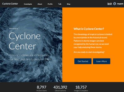
The homepage of the Cyclone Center project.

An official website of the United States government
The .gov means it’s official.
Federal government websites always use a .gov or .mil domain. Before sharing sensitive information online, make sure you’re on a .gov or .mil site by inspecting your browser’s address (or “location”) bar.
This site is also protected by an SSL (Secure Sockets Layer) certificate that’s been signed by the U.S. government. The https:// means all transmitted data is encrypted — in other words, any information or browsing history that you provide is transmitted securely.
The homepage of the Cyclone Center project.
Are tropical cyclones (what we in the Americas call hurricanes) becoming stronger? How is their intensity changing in a changing world? Unfortunately, these are questions science can’t answer with much certainty right now.
Hurricanes can have catastrophic and long-lasting impacts on coastal regions around the world. Hurricanes are classified by maximum wind speed, a value usually estimated from satellite imagery. Scientists use special techniques to estimate storm intensity from satellite imagery based on patterns recognized by the human eye.
Since the 1970s, scientists have amassed more than 300,000 satellite images of tropical cyclones, with more than 10,000 new images added yearly. If we could analyze this massive quantity of imagery, we might be able to better understand whether and how tropical cyclones are changing. But the remaining workload is far too great for scientists to handle alone.
Through a partnership with Zooniverse, the University of North Carolina at Asheville, and the Cooperative Institute for Climate Studies in North Carolina, the National Centers for Environmental Information (formerly the National Climatic Data Center in Asheville, North Carolina) at the National Oceanic and Atmospheric Administration is co-sponsoring a crowdsourcing website called Cyclone Center. By recruiting thousands of classifiers and comparing results, scientists can analyze images faster than ever before.
Download this case study (PDF, 169KB)
Website: Cyclone Center
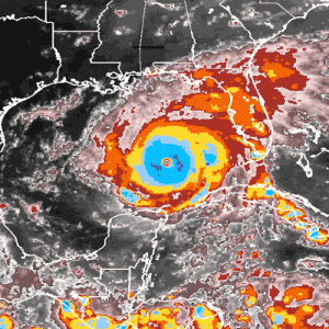
An image of Hurricane Rita (from 2005) as seen using the Cyclone Center color scheme.
Volunteers get started by visiting the Cyclone Center website. After a brief tutorial, they answer basic questions about satellite imagery.
The images volunteers see are from infrared sensors on weather satellites. These sensors measure the temperature at the tops of clouds. Cloud-top temperatures are important because they give an idea of how tall the clouds are. Cold clouds are taller than warm clouds since temperature decreases with height. The colder, taller clouds are responsible for the heavy rain and thunderstorms that drive tropical cyclones.
Even more important are questions about the shapes of clouds in the satellite imagery. Scientists have found that cloud formations are related to hurricane intensity.
By comparing the classifications made by different volunteers, scientists can discard the outliers and choose the correct classifications. The project is designed to help resolve differences in the global tropical cyclone record and improve our understanding of how the nature of these storms may be changing through time.
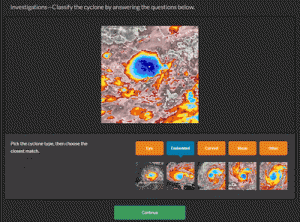
A sample snapshot during the classification of a satellite image. The questions are simple and straightforward. This example shows the user selecting the type of embedded center that is characteristic of the large sample image.
The biggest hurdle was translating techniques that professionals use to analyze satellite imagery into something that anyone can do. In the 1970s, Vern Dvorak developed a satellite analysis technique to discern hurricane intensity from satellite imagery using a multi-step flowchart. Each analysis can take several minutes and is generally done by forecasters or tropical meteorologists.
By transforming this technique into a set of questions for the general public, Cyclone Center met the challenge. Volunteers can complete an image assessment in a minute or less. Some volunteers have completed more than 10,000 classifications — the equivalent of assessing every image of every tropical cyclone in a given year!
Another challenge was creating the satellite imagery. In the Dvorak analysis, experts assessed satellite imagery based on their professional experience. Volunteers don’t have time to develop that experience, so Cyclone Center developed a color scale that matched the Dvorak technique. The project also worked with online tools to ensure that people with colorblindness (which affects about 1 in 10 males) could easily discern the color scale.
Another challenge was community acceptance. Some tropical experts who spent a lifetime studying and analyzing the data considered the idea that volunteers could analyze satellite imagery absurd. Cyclone Center’s approach was to move slowly, keep the tropical community informed, and assure the experts that it follows the standard scientific process involving peer review. The Center used tropical cyclone email lists to send information and answer questions, and it presented the Center’s approach at scientific conferences. Cyclone Center has a peer-reviewed journal article in the most widely read meteorological journal (the Bulletin of the American Meteorological Society).
More than 20,000 volunteers have classified over 450,000 images of cyclones, giving scientists a better picture of historical storms and their relative strengths. Crowdsourcing is helping the scientific community reanalyze the global hurricane record. By developing a series of simple questions that citizen scientists can answer on a website, the project is working toward a new dataset that resolves intensity discrepancies in recent tropical cyclones. Preliminary results suggest that the performance of human classifiers in some cases exceeds the performance of an automated technique applied to the same data.
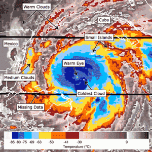
An annotated image of a hurricane, describing the different features that might be seen in a hurricane.
The Cyclone Center case study illustrates the following steps in the Federal Citizen Science and Crowdsourcing Toolkit:
Kenneth Knapp
Email: ken.knapp@noaa.gov
Christopher Hennon
Email: chennon@unca.edu