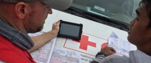
OpenStreetMap in use during the Typhoon Haiyan response. Photo credit: American Red Cross.

An official website of the United States government
The .gov means it’s official.
Federal government websites always use a .gov or .mil domain. Before sharing sensitive information online, make sure you’re on a .gov or .mil site by inspecting your browser’s address (or “location”) bar.
This site is also protected by an SSL (Secure Sockets Layer) certificate that’s been signed by the U.S. government. The https:// means all transmitted data is encrypted — in other words, any information or browsing history that you provide is transmitted securely.
OpenStreetMap in use during the Typhoon Haiyan response. Photo credit: American Red Cross.
When a catastrophic earthquake hit Haiti in 2010, map data critical for response efforts were incomplete and hard to access. In a matter of days, hundreds of volunteers created the map for Port au Prince in OpenStreetMap, greatly facilitating recovery efforts.
High-quality geographic data helps organizations and communities make important environmental, economic and disaster response decisions. In many places around the world, the information is incomplete or non-existent.
In open (or crowdsourced) mapping, volunteers work together to create a free and open map of the world for purposes that range from mundane to critical. MapGive supports a global open mapping initiative with learning tools, satellite imagery, technical services, event support and networks in the global OpenStreetMap and humanitarian communities.
Download this case study (PDF, 79KB)
Website: MapGive
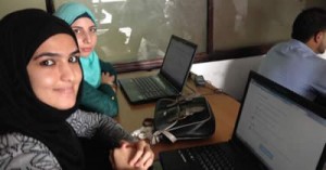
Ebola mapathon in Ramallah. Photo credit: U.S. Consulate General, Jerusalem.
MapGive is the U.S. State Department’s program for supporting OpenStreetMap. Contributors map infrastructure data in OpenStreetMap, including the line of roads, building footprints, points of services and amenities, land uses such as fields or industrial areas, and many other things. The Internet has many free maps, but the underlying data in many maps are not available for public use due to legal and technical restrictions. Through open mapping, anyone anywhere can sign up to learn mapping tools and start contributing, and anyone can use the open map data. During humanitarian response, large numbers of volunteers divide up work through the OSM Tasking Manager.
Many entities work in the OpenStreetMap community, including governments, companies, non-profit organizations and schools. The core infrastructure of OpenStreetMap (the servers, intellectual property and domain) is maintained by the OSM Foundation, a non-profit organization based in the United Kingdom. The Humanitarian OpenStreetMap Team connects the OpenStreetMap community with groups working on humanitarian response and economic development.
The MapGive initiative began with Imagery to the Crowd, which offers high-resolution commercial satellite imagery services in a format that volunteers can easily map into OpenStreetMap. With a focus on humanitarian and development applications, MapGive is run by the State Department’s Humanitarian Information Unit. The unit gives information to decisionmakers and partners in preparation for and response to humanitarian emergencies worldwide. It also supports innovative technologies and best practices for humanitarian information management.

Ebola mapathon in Ramallah. Photo credit: U.S. Consulate General, Jerusalem.
OpenStreetMap is an extremely dynamic community, with a constantly evolving and growing number of actors, events, new communities and related software projects. It takes an active learning approach to understand this landscape, build relationships and find ways to contribute (and continue to contribute) as an institution. For instance, MapGive has worked closely with the Humanitarian OpenStreetMap Team, mappers and other providers of imagery services to develop new processes and coordinate effectively when fulfilling imagery requests.
Another challenge has been keeping aligned with other institutions, both inside and outside of government. Many offices work with OpenStreetMap. Users all map together in the same database, but due to their different organizational structures, they don’t always work together on planning, communication strategies and development of resources and tools. The State Department, along with partners such as the U.S. Agency for International Development, Peace Corps, World Bank and American Red Cross, has been working to bridge the gap.
Map data are key to assisting humanitarian and development missions. First responders to humanitarian emergencies use maps to find their way through unfamiliar and changed landscapes, and decisionmakers use maps to prepare their communities in the event of a disaster. Successes include support for the Ebola OpenStreetMap response in West Africa; for the Nepal earthquake; and for Connect Camps, a program in Africa that builds on the Young African Leaders Initiative.
Everyone has an overwhelming urge to help when they see suffering, which is so immediate in today’s wired planet. Through OpenStreetMap, volunteers can make a powerful contribution with no more than an Internet connection and basic computer skills, even if they do not live in the area they are mapping.
MapGive has supported many humanitarian responses, notably the Ebola epidemic in Africa and the Nepal earthquake in April 2015. Volunteers have contributed thousands of kilometers of imagery services for digitization into OpenStreetMap; MapGive has also offered analysis and visualizations of contributions, extensive networking between OpenStreetMap and humanitarian communities, and support for events. During the Ramallah #map4ebola event, for example, the U.S. consulate in Jerusalem sponsored students mapping for West Africa; and during the Lahore mapathon, students supported by the consulate there contributed data for Nepal. In May, the first-ever White House Mapathon highlighted these and other events.
The MapGive case study illustrates the following steps in the Federal Citizen Science and Crowdsourcing Toolkit:
Benson Wilder
Email: wilderbf@state.gov