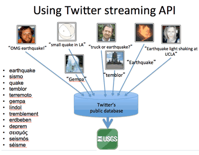
Diagram showing how tweets are collected using the Twitter streaming API, merged with other earthquake data in the database, and then used to send a TED tweet. Credit: U.S. Geological Survey.

An official website of the United States government
The .gov means it’s official.
Federal government websites always use a .gov or .mil domain. Before sharing sensitive information online, make sure you’re on a .gov or .mil site by inspecting your browser’s address (or “location”) bar.
This site is also protected by an SSL (Secure Sockets Layer) certificate that’s been signed by the U.S. government. The https:// means all transmitted data is encrypted — in other words, any information or browsing history that you provide is transmitted securely.
Diagram showing how tweets are collected using the Twitter streaming API, merged with other earthquake data in the database, and then used to send a TED tweet. Credit: U.S. Geological Survey.
Within seconds of an earthquake, many people report what they felt through social networks such as Twitter. By contrast, scientific alerts can take up to 20 minutes, depending on the size and location of the earthquake.
Tweet Earthquake Dispatch uses social networks to support earthquake response and report information about related hazards. Through the TED system, the U.S. Geological Survey’s National Earthquake Information Center analyzes data from social networks to detect earthquakes within seconds of their occurrence. It also uses TED to assess citizen reports of earthquakes alongside corresponding scientific reports and to tailor its own social networking about earthquakes to the corresponding level of public interest.
Download this case study (PDF, 79KB)
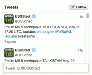
Snapshot of the tweets that the TED system sends out to followers.
TED harvests real-time tweets through a continuous connection to Twitter. The system applies a query parameter to reduce the stream to tweets that contain the keyword earthquake in several languages.
The system also applies other data-cleaning techniques. It merges tweets, ordering them, accounting for duplicates and filling any data gaps. Data from aggregators — users who redistribute secondhand earthquake information — are removed from the dataset.
For each tweet filtered by keyword, TED archives the creation time and text, the Twitter user location, the Twitter tweet ID, and the time the tweet appeared in the TED database. The system also uses the Yahoo Maps API Geocoding Service to estimate the latitude and longitude of the sender’s location, if provided.
Around the clock, TED also ingests seismically derived earthquake information from the USGS’s near-real-time internal global earthquake stream. TED archives the earthquake time, region, magnitude and hypocenter (latitude, longitude and depth). It also records the source of the scientifically derived earthquake information.
For earthquakes that have been verified using seismic instruments, TED subsequently sends out a tweet to followers with basic information about the earthquake.
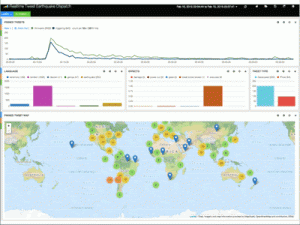
The TED operational monitoring display, showing real-time tweets that contain the keywords that TED uses to determine that an earthquake has occurred somewhere. Credit: U.S. Geological Survey.
TED supports the mission of the USGS National Earthquake Information Center by providing rapid information about the occurrence of an earthquake. This information augments but does not replace the instrumental data collected by the USGS. TED provides no quantitative information about earthquake epicenter and magnitude, for example, and the geographic location it gives is not always reliable. Without verified quantitative data, the National Earthquake Information Center can neither issue public alerts nor trigger direct response measures.
The main advantage of mining citizen reports through Twitter is speed. Rapid tweet-based earthquake detection can potentially fill the gap between the time when an earthquake occurs and the time when seismically derived information becomes available.
TED detects two to three earthquakes a day, on average. Especially in regions with few seismometers, TED reports often come in before traditional seismic networks detect an earthquake, giving seismologists early warning. TED sometimes detects earthquakes entirely missed by USGS’s automatic processing system, thereby increasing the number of felt events known to the agency. In addition, the tweet text and attached images sometimes offer a rapid qualitative assessment of an earthquake’s impact.
The Tweet Earthquake Dispatch case study illustrates the following step in the Federal Citizen Science and Crowdsourcing Toolkit:
Paul Earle
Email: pearle@usgs.gov